
Miami Beach - Resiliency GIS Analyses + Historic Districts
Miami Beach, Florida
Miami Beach sits at an average elevation of approximately four feet above sea level and has already undertaken extensive experimentation with resiliency and climate-adaptation infrastructure. This vulnerability is underscored by the scale of economic exposure: beachfront property in Miami-Dade County is estimated at approximately $15 billion. This research analyzes the chronological development of historic preservation practices in Miami Beach as a case study to assess how past preservation frameworks, regulatory decisions, and design interventions can inform future approaches to citywide resiliency planning.


Current conditions and projected future constraints necessitate timely and proactive planning. Recent assessments indicate that approximately 28 percent of historic resources are at risk by 2050, increasing to 56 percent by 2100. A critical understanding of how municipal policies were previously implemented—including the compromises required and public responses to past challenges—can inform Miami Beach’s continued leadership in addressing the tensions between climate change resilience and historic resource protection.
Current conditions and projected future constraints necessitate timely and proactive planning. Recent assessments indicate that approximately 28 percent of historic resources are at risk by 2050, increasing to 56 percent by 2100. A critical understanding of how municipal policies were previously implemented—including the compromises required and public responses to past challenges—can inform Miami Beach’s continued leadership in addressing the tensions between climate change resilience and historic resource protection. The historical success of economic and architectural revitalization in Miami Beach through historic preservation provides a valuable framework that should be leveraged as a future societal benefit, particularly in advancing sustainability objectives amid the inevitability of sea-level rise. Accordingly, the City of Miami Beach should formally integrate historic preservation into its resiliency planning framework, enabling the adaptation of historic structures to be funded and executed as municipal capital improvement projects.

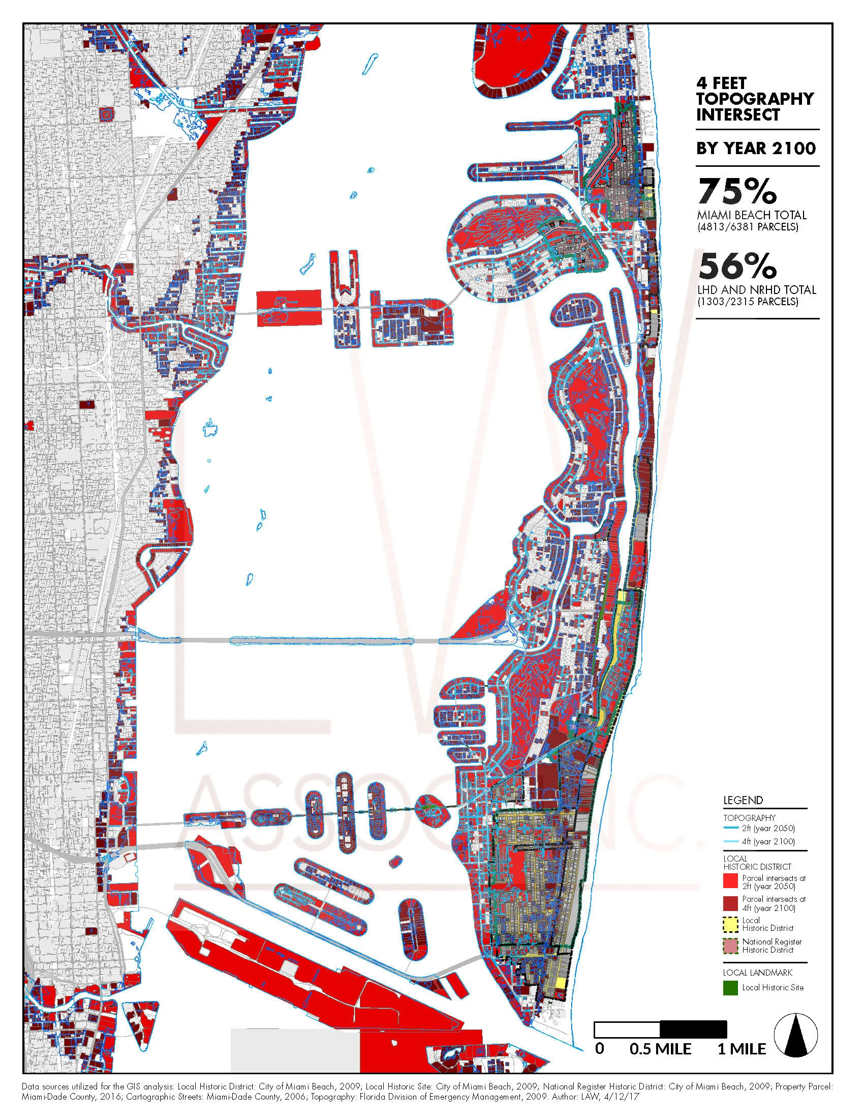
Geospatial analysis underscores the significance of historic preservation regulation in Miami Beach, where 29.81 percent of buildings and 25.02 percent of land area are subject to local historic designation. Of the city’s 6,381 tax parcels, 2,315 are located within either local or National Register historic districts. Parcel-level data intersected with projected sea-level rise at two feet (2050) and four feet (2100) indicates that 35 percent and 75 percent of all parcels, respectively, are at risk, with even higher exposure within historic districts. This analysis enables the identification of priority areas for climate adaptation based on the concentration of affected historic resources. Miami Beach’s long-standing culture of resilience is rooted in its entrepreneurial governance and capacity to enact policy innovations driven by economic development and tourism. Functioning effectively as a self-directed urban entity, the city has demonstrated leadership in balancing quality-of-life objectives, historic preservation, and climate adaptation. This case study examines how historic preservation has historically served as a catalyst for economic and architectural revitalization, and how these mechanisms can be strategically integrated into future resiliency planning in response to accelerating sea-level rise.